But the map said there was a road


Nancy and I went on a great ride today from Montpelier up through Elmore on to some wild territory that was not what we had planned on, but enjoyed a lot (once we got through).
Rt. 12 heading north from Montpelier was really nice as the elevation rises and the forest becomes more and more pine and the houses and cars drift off behind. Another couple on bikes passed us and then bounced ahead and back for the better part of the ride up to Elmore.
Just before Elmore we took a right onto a dirt road and headed into less familiar, but interesting, roads. Within a mile of leaving rt. 12 I had mis-directed us and it wasn't until a couple miles later that we realized the mistake. Nancy had wisely brought along the necessary pages from a Vermont Gazetteer map book and we were able to deduce pretty quickly that the road we were on would take us through to where we had planned to go anyway, so we forged ahead.
What we didn't really consider was the legend. In fact we didn't have it with us, but casually assumed that since the "road" was a continuous double-dashed line we'd be good. Within in mile or so, the travelled dirt road ended and we passed a sign saying "bridge out-not for travel" or something to that effect. I thought if anything this was enticing, since we might have to portage a bit.
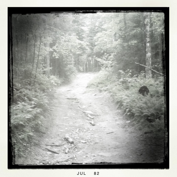
Quickly the way turned to very rough washed out road that required mountain bike handling (up off the seat, bouncy leg position, heavy on the rear brake) going down some really steep and ragged path. It was really fun and great to be riding out in the woods. It was sort of like going on a hike, but on bikes.
Like any dubious adventure, there comes a point where you realize you've got yourself pretty far into something that then starts to maybe seem a little uncertain. We eventually went over a little bridge, looked at the map, and assured ourselves that we knew where we were. The route we were travelling was a combo VAST (Vermont Association of Snow Travellers) trail, four-wheeler, and dirt bike trail.
With lots of up, and lots of down we continued and eventually ended up on Woodbury Mountain Road (which was our original intended route) and felt some relief to be back on a regular dirt road. It should be noted that this road was still a class-four road and still part of the VAST network. With the edge of anxiety diminished, we decided to travel this road south towards Maple Corner where we would take a rest and get some food and water. Looking more carefully at the map this time, we could see that what we were on was a double-dashed road, but would become a double-dash double-dot dot road. In other words, returning to similar trail conditions as before. We decided to go for it and really enjoyed the pleasure of being on a road with no traffic whatsoever and a good enough surface to make reasonable headway, all in the proverbial middle of nowhere.
Of course the road did become a boulder/ditch/mud/gravel/sand/root path once again, but we knew we were headed in the right direction, so enjoyed the experience. In all honesty, my chief worry was imagining running into unfriendly people in such a remote and unfamiliar area.
In due time we heard the rumble and strain of motor vehicles off in the distance.
When we finally came upon the source, we were stunned to see not one, not two, not three, but six jacked up trucks with massive wheels slowly navigating the trail in an impressive caravan. I admit to feeling quite vulnerable as I saw this impressive fleet slowly bouncing, bumping and climbing it's way down towards us.
Of course the folks were all good humored and we exchanged friendly hellos as they passed by one-by-one.
We continued on our way, sometimes walking our bikes, sometimes riding.
Some time on another fleet of vehicles came through. This time they were older folks and all driving Jeeps, including a couple of vintage vehicles that were a joy to see in this environment.
After nearly ten miles of challenging terrain we finally met County Road and congratulated each other for coming through quite a challenge. The rest of our ride back into town was pleasant and unremarkable. We had left for this ride expecting a reasonably straightforward excursion and ended up with a much longer and more adventurous experience than we had bargained for.
We arrived back to our car in Montpelier with a nice note from my sister reminding us to feed their dog and wishing us a good ride. Heading home we considered what lessons were to be learned from the day:
- Bring a paper map
- Check the type of road, not just that it exists
- Bring plenty of food and water
I observed to Nancy that had we known what we were going into we most likely wouldn't have done it and that would have been a shame, so its sort of a conundrum in that respect that better preparation might have negated the whole thing.
I strongly resist the notion that bikes have to be either "mountain bikes" or "road bikes", believing the difference is really a false dichotomy. A bike can be exceedingly capable of excellent performance on both smooth paved roads and rough mountainous dirt paths. Today reaffirmed that with wide tires and wide gearing you can really go much further than current conventional wisdom would expect.
(An interesting aside to our day: We had a chance encounter with fellow randonneur Greg, who I have met briefly at recent brevets and exchanged blog comments with over time. It was great to have a chance to chat and say hi in person. Shortly before seeing Greg we had crossed paths with old acquaintances Jay and Dot who I worked with a few years ago at Yestermorrow. Jay is keeping a blog about his renovation project on their house in Philidelphia that I have been enjoying keeping up with. It occurred to us that in both cases our real-world connections with these folks are fueled and reinforced by our blogging activities.)


Comments
Those are great photos...Holga camera or digital filter?
The images are made with the Hipstamatic app on an iPod touch. Fun stuff!
i wonder if you can share the name of the road. would love to stitch together many more of these old trails and roads...
see you at the fall classic!